HOSTED BY: 1 AIR TRAVEL
Getting from A to B by car is filled with variables. Do you want to go on the highway? Are you willing to pay a toll? What’s the traffic like? Your route can often change depending on the answers to these questions and how far you’re traveling.
When flying between two airports, you may assume the quickest route would be the most direct line or “as the crow flies.” In reality, this is not always the case. If you’ve ever watched the animated flight map while flying as a passenger, you may have noticed that a flight rarely takes the exact “straight line” route. The same flight between the same cities could actually fly considerably different routes from day to day, month to month.
Why is this?
Shortest route vs. quickest route
Before we dive into this topic, it’s important to note the difference between the shortest route and the quickest route and why the two may not necessarily be the same.
When flying from London to San Francisco, you might expect to take off from London; fly over Cornwall, England; cross the Atlantic to Eastern Canada; and zoom over the central part of the U.S. to San Francisco.
However, the reality is quite different, as you can see in the image below.
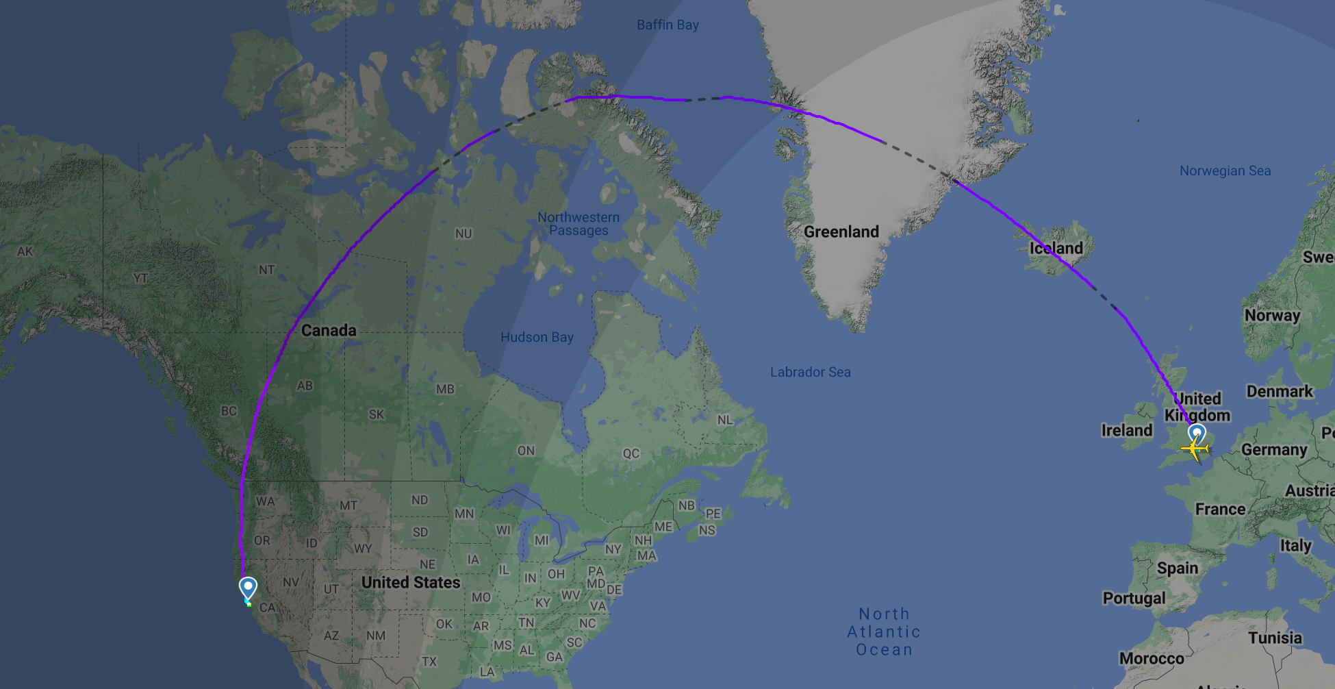
A United Airlines flight between London and San Francisco. FLIGHTRADAR24
Instead of the expected direct line, the flight seems to go off in the opposite direction and take a rather scenic route over Greenland (which is stunning from the air, by the way) and the northern reaches of Canada. Why?
The answer lies in the fact that the Earth isn’t flat (sorry to that small percentage of you) as depicted in Google Maps. If you take a piece of string and put it on a globe between the two cities, you’ll find that the shortest route is indeed up over Greenland and is known as a Great Circle, as depicted in the image below.
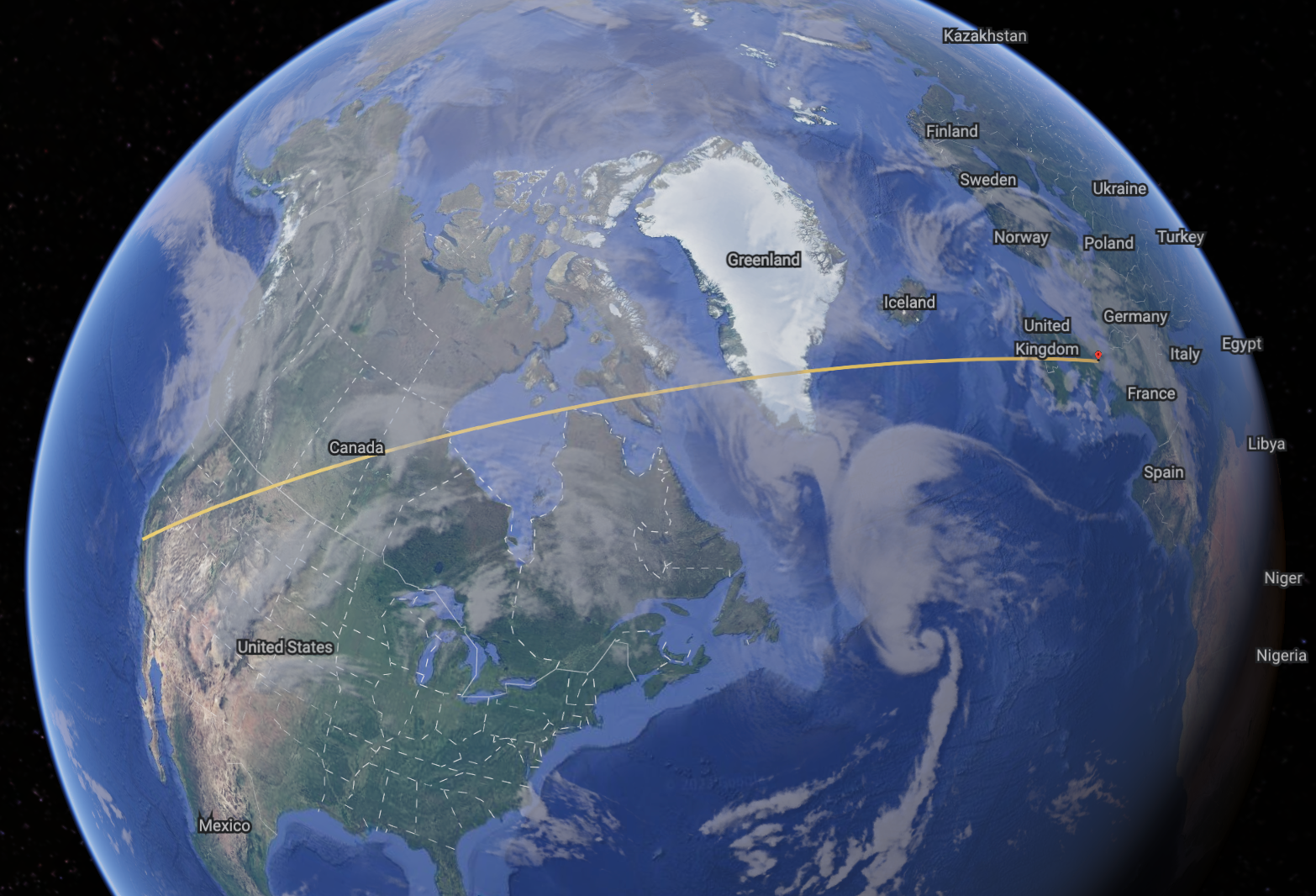
The Great Circle between LHR and SFO. GOOGLE EARTH
However, if you look closely at the difference between the two images above, you’ll notice that the route that the United flight took wasn’t exactly the same as the Great Circle route.
Just because a certain route is the shortest route, due to a number of variables, it may not necessarily be the quickest route.
Related: Flight planning: The unseen detail behind every flight
Winds
One of the biggest variables in this equation is the winds. For the most part, global winds move around the earth from west to east due to the fact that the earth is spinning. This means that when flying westbound, aircraft tend to travel into head winds and when flying eastbound, they tend to encounter tail winds. So what does this mean for aircraft?
I’m sure you’ve been out walking on a particularly windy day and as you turn a corner, you suddenly find yourself battling a stiff head wind. Now, instead of walking easily, you have to put extra effort into keeping up the pace, using more energy in the process.
Conversely, if you turn in the opposite direction, you’ll suddenly find that your pace picks up. It’s the same for aircraft.
When flying west, we are normally flying against the wind, so our speed slows down and we use more fuel. When flying east, the wind tends to be behind us, increasing our groundspeed. This reduces our flight time and the amount of fuel we use.
This is why the eastbound part of a particular city pairing is invariably quicker than the westbound trip.
These winds are most noticeable in the areas of jet streams — fairly narrow bands of extremely fast-moving air. They are depicted by the green lines in the graphic below.
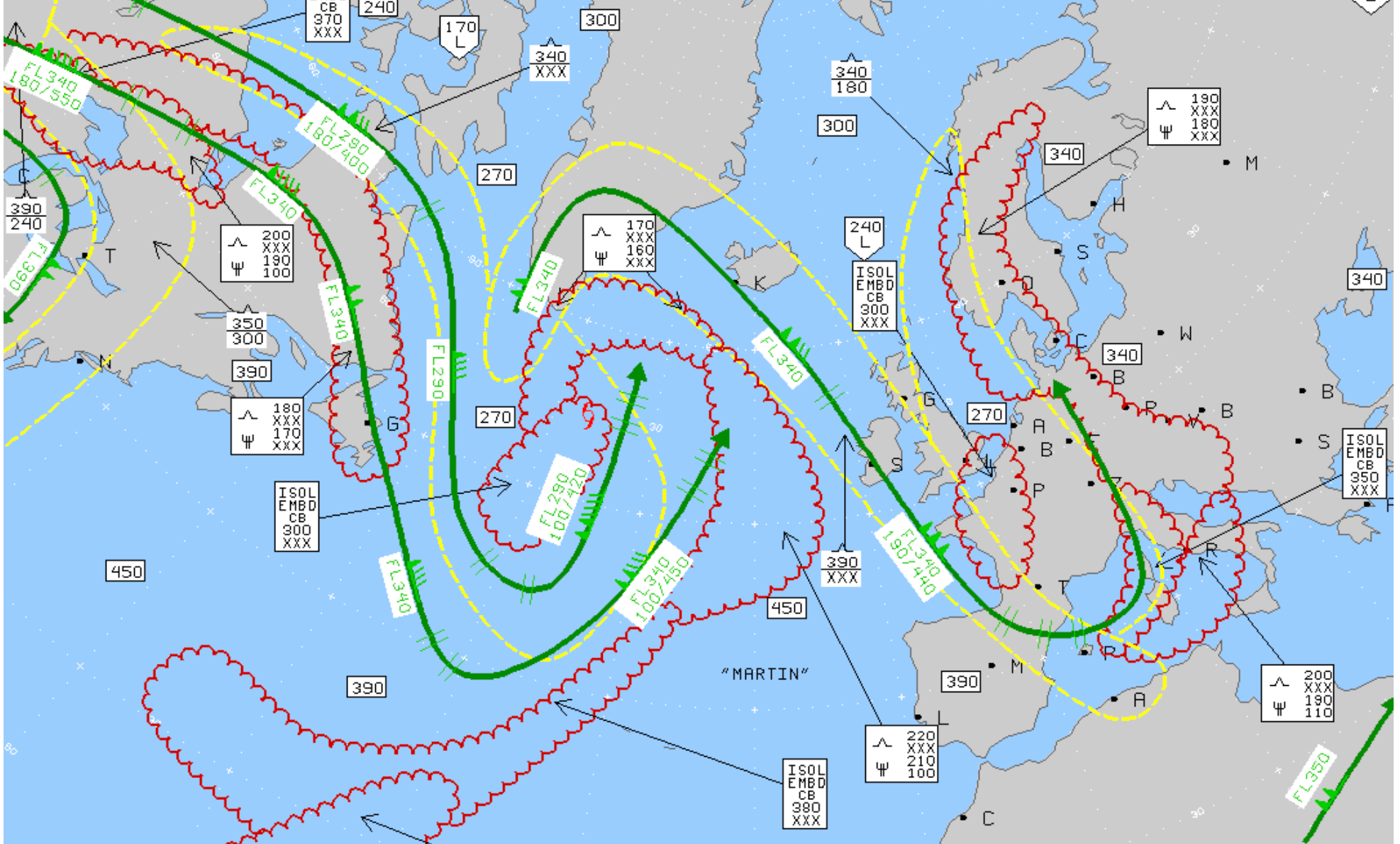
A typical North Atlantic weather chart showing jet streams in green. AVIATIONWEATHER.GOV
Even though the course of these jet streams isn’t exactly west to east, it’s clear to see that their overall path does follow that rule. By virtue of weather systems, these jet streams will change in strength and location from day to day, which is why flight routes vary.
When flying westbound, airline flight planning departments do their best to avoid the strongest of these jet streams. This may mean flying a route that takes the aircraft quite a long way off the Great Circle track but ultimately results in a quicker flight time than the route on the Great Circle line.
Related: How the atmosphere and winds affect your flight
When flying eastbound, the opposite is true. Flight planners will do their best to get aircraft into the core of the jet streams to take advantage of the strong tail winds, even if it means flying more mileage over the ground. This is because the strong tail winds will increase the groundspeed, reducing the flight time and the amount of fuel used.
A great visualization of this is in the clip below from “Finding Nemo”:
Traffic volumes
This clip also demonstrates another variable in the route a flight may take on a particular day: the amount of traffic.
It may seem ludicrous that there could be traffic jams in the sky. However, because there is a minimum distance required between aircraft, traffic jams do indeed occur when too many aircraft are trying to get through a certain area at the same time.
However, the beauty of internationally coordinated flight planning systems is that air traffic controllers can see where these issues may occur. Due to the geopolitical situation in a number of countries around the world at the moment, the routes that aircraft can take — particularly between Europe and southern and east Asia — are limited.
If air traffic control agencies notice that there will be a backup in a particular area at a certain time, they will place a departure time restriction on some aircraft even before they leave the gate. In the industry, this is known as a slot.
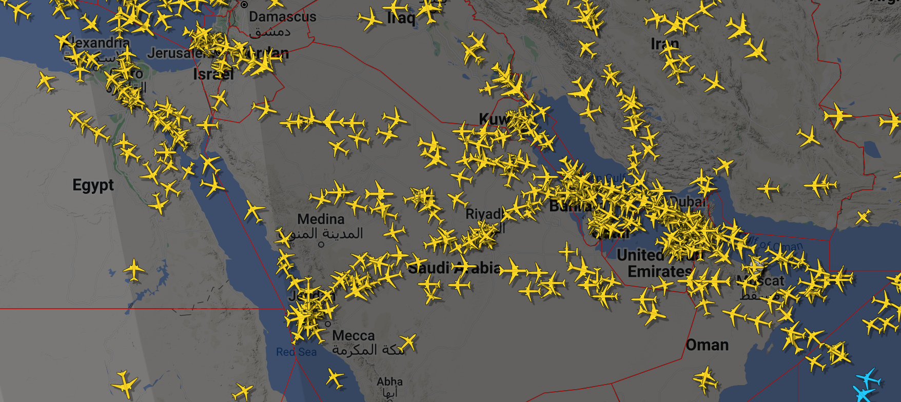
Routes between Europe and India and the Far East are prone to congestion. FLIGHTRADAR 24
If this happens, the flight planners have two options: They can decide to wait for the slot restriction and take the originally planned route, or they can look to reroute the aircraft through airspace that is less congested.
The option they choose will ultimately come down to a number of variables. These variables include the cost difference in fuel between the two routes, the difference in time, effects on the on-time performance of the flight and subsequent flights, and the cost of any passengers missing connections.
If the slot time isn’t too far away, it may be better to wait for it to come around. If it’s hours away, as is sometimes the case during a busy summer, a reroute may be the best option.
Geopolitical issues
As mentioned, geopolitical issues have a major effect on the routes that aircraft can and can not fly. At the moment, most airlines are banned from flying through Russian airspace. Additionally, the security situation on the ground in a number of African and Middle Eastern countries prohibits aircraft from flying through their airspace.
As a result, the route a flight takes on a particular day depends heavily on these factors. Flying 43,000 feet above a certain country may be safe, but flight planners and pilots always have to think about potential technical issues that could require us to descend and divert the aircraft.
As a result, airlines constantly stay on top of the latest safety and security information around the world to ensure that their aircraft, passengers and crews never end up in such a situation.
Thunderstorms and turbulence
Not only do jet streams bring strong winds, but they can also generate turbulence — as indicated by the dotted yellow line in the chart at the top. While it can be quite smooth in the core of the jet stream, the turbulence can be quite rough on the edges. This is particularly true when crossing a jet stream at 90 degrees.
If the planned route of a flight will pass through an area with a severe forecast that could produce turbulence, pilots will often spot it during a preflight briefing. In this scenario, we would make a quick call to flight planning to alert them to this threat and ask if there is another route that we can take.
Depending on other airspace restrictions, such as those listed above, flight planners may then be able to find a new route that keeps us away from the worst of the turbulence.
It’s the same for forecast thunderstorms. Crossing the equator we fly through an area called the Inter Tropical Convergence Zone. Here, rotating air masses converge and the only way for them to go is up. These upward-moving winds take moisture with them and form thunderstorms that can reach 60,000 feet and beyond.
We can end up flying hundreds of miles off-course to avoid these areas. As a result, if storms are in the forecast for a particular area, the flight route will avoid this area as much as possible.
Of course, there’s no guarantee that storms won’t also develop along the route we are flying. However, by planning ahead and using accurate forecasts, we can avoid the worst areas.
Related: Can planes fly in thunderstorms? Here’s what a pilot says
Bottom line
In the life of an airline pilot, no two days are ever the same nor are the routes that we fly. The biggest reason for a difference in routing tends to be the winds. When flying between London and Miami, the route can vary massively depending on where the jet streams are located.
With strong jet streams in the middle of the Atlantic, the flight will most likely route via the northern Atlantic and then down the Eastern Seaboard. The return flight will then make the most of those winds by flying straight across the pond.
However, if the jet streams are located farther north, it may be a better option to fly the London-to-Miami route straight out across the middle of the water.
We know that each time we fly to a destination, the route will always be different in some way from the last time we visited due to high traffic density, geopolitical issues or weather.
Title: Why the quickest flight route might not always be the obvious one
Sourced From: thepointsguy.com/news/why-do-flight-routes-differ/
Published Date: Mon, 07 Nov 2022 19:30:26 +0000
No comments:
Post a Comment